Latest Post

Search

Breathtaking Glacial Waterfalls in Svalbard, Norway

Posted By Kirti Ranjan Nayak on Sunday 21 April 2013 | 17:25

#1
Photo credit


Svalbard is an archipelago in the Arctic Ocean, constituting the northernmost part of Norway. It is located about halfway between mainland Norway and the North Pole. Despite being so close to the North Pole, Svalbard remains comparatively warm, thanks to the warming effect of the Gulf Stream, which makes it habitable. In fact, Svalbard is the northernmost permanently inhabited region on the planet. 
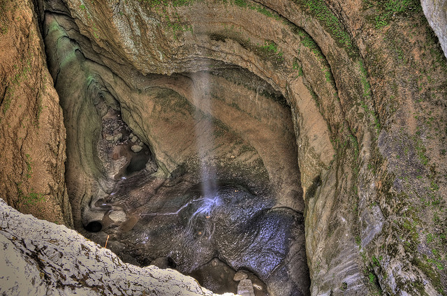
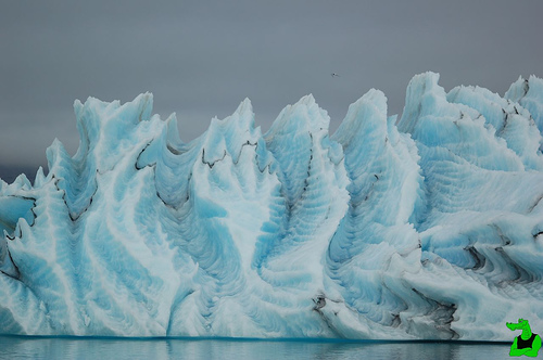
Svalbard is one of the most beautiful places on earth, nearly 60% of which is covered by magnificent glaciers and waterfalls with many outlet glaciers ending up in the sea. When snow and ice melts many of these glaciers have small beautiful waterfalls. Most of Svalbard is barren rock but during the short summer, the melting snow in the milder parts of the islands gives rise to vast stretches of tundra vegetation, sometimes dotted with delicate flowers.


Svalbard is home to seven national parks and twenty-three nature reserves that covers two-thirds of the archipelago, protecting the largely untouched, yet fragile, environment. Svalbard is a breeding ground for many seabirds, and also features polar bears, short legged reindeer, polar foxes, whales, seals and walruses. Svalbard is renowned for its variety of birds, including Arctic Terns, Arctic Fulmar and Puffins. Whales can be spotted off the coastlines particularly during late summer. Humpback whales, Orcas, Beluga Whales, and Narwhals all frequent the ocean waters near Svalbard.

Photo credit

Photo credit

Photo credit

Photo credit

Photo credit
#2

Zhangye Danxia Landform Geological Park, China.

Posted By Kirti Ranjan Nayak on Sunday 31 March 2013 | 18:08

#1

The Zhangye Danxia landform is also known as the eye candy of Zhangye. Many artists envy this masterpiece as it appears like a perfect painting on canvas that spans more than 400 square kilometers in the Gansu Province in northwest China. It is as though either an artist had accidentally spilled his color palette on it with all colors imaginable and let it drip or purposely created this multicolored masterpiece. There are several danxia landforms in China but this one in Zhangye is known as the largest and the most typical, and referred by geologists as the “window lattice and palace-shaped danxia topography”.

"How did mother nature come up with such a magnificent work of art?" you might ask. Geologists would tell you that this type of landform known as danxia is a result of a combination of active movements beneath the Earth’s crust in concurrence with exogenous forces which act on the surface, therefore, creating rock layers that differ in color, texture, shape, size and pattern. These differences, however, uniquely characterize this scenery; creating a terrain composed of towering peaks, jagged cliffs, gaping cave holes, rugged rock pillars and stone walls that go from rough to smooth at various points. It gives an impression of an artistic creation that was carefully thought out yet creatively disorganized at the same time.

The area is fast becoming a popular tourist attraction for the sleepy town of Zhangye. A number of boardwalks and roads have been built to encourage visitors to explore the amazing rock formations.

The unusual colours of the rocks are the result of red sandstone and mineral deposits being laid down over 24 million years. Picture: Amos Chapple / Rex Features


The resulting 'layer cake' was then buckled by the same tectonic plates responsible for parts of the Himalayan mountains. Wind and rain finished the job by carving weird and wonderful shapes including natural pillars, towers, ravines, valleys and waterfalls - that differ in colour, texture, shape, size and pattern.
Picture: Amos Chapple / Rex Features


A boy walks through, with a feel of Martian landscape.


People enjoying the sweet red of the unique hilly terrain featuring red rocks and cliffs of the danxia landform in the mountainous areas of the Zhangye Geology Park near Zhangye in northwest China's Gansu Province.

More info: http://www.chinahighlights.com/zhangye/attraction/danxia-landform-geological-park.htm
#2

The Krubera Cave in Abkhazia: World's Deepest Cave

Posted By Kirti Ranjan Nayak on Saturday 16 March 2013 | 18:19

#1

The Krubera Cave (or the Voronya Cave, sometimes spelled the Voronja Cave) is the deepest known cave on Earth. It is located in the Arabika Massif of the Gagrinsky Range of the Western Caucasus, in the Gagra district of Abkhazia, near the Black Sea. "Voronya Cave" means "Crows' Cave" in Russian. This name was given after the noted Russian geographer Alexander Kruber. 

The cave is considered as the “Everest of the caves”. The total length of cave passages reaches 13,232 m, the depth is -2,191m ± 20 metres (-7,188 ± 66 ft). Krubera Cave became the world’s deepest cave in 2001, when Ukrainian speleogolists reached a depth of 1710m, thereby exceeding the previous known reigning champion in the Austrian Alps. At a depth of 1500m a subterranean waterfall of near-freezing water has flooded a branch of the cave system, while the main branch continues to a depth of 2140m, where a terminal siphon marks the end of the cave. The approach to the extreme depths of the cave was accomplished, using ropes, through a complex of pathways determined on the basis of water streaming through the cave.
.
 

First an intrepid team of explorers broke the depth record in Krubera - near the Black Sea coast. Then a second team went deeper. The Ukrainian speleologists needed a staggering 14 days to reach the siphon at the end of the cave. A number of endemic fauna has been found at all levels of depth within the cave, including spiders, scorpions, beetles, as well as stygofauna like shrimps and amphipods.

Some of the spelunkers had to dive through frigid water (two degrees Celsius) in order to reach the deepest sections of the cave. While they were in the cave, the explorers were subject to some unexpected developments: a flash underground flood, forcing them to remain isolated from any contacts for about 30 hours. Its a limestone formation dating back to the Age of Dinosaurs.

The Arabika massif in the Western Caucasus constitutes one of the largest karst massifs on Earth, but despite its enormous potential to scientists, the area, including Krubera Cave, has been woefully under-explored. One of the reasons is the remoteness of the area, which is only accessible for up to four months a year, but the main obstacle for scientists have been the numerous political conflicts in Abkhazia, which continue until today.


#2

Amazing Grotto: The Enchanted Well, Brazil

Posted By Kirti Ranjan Nayak on Sunday 3 March 2013 | 23:44

#1


Poço Encantado, or Enchanted Well, is located in the Chapada Diamantina National Park in Bahia state, approximately 400 kilometres inland from Salvador, the capital city of Bahia. This giant sunken pool is 120 feet deep and the water is so transparent the rocks and ancient tree trunks are visible on the bottom.

When the sun is just right, the sunlight ray reflected by minerals in the water, especially magnesium, creates an unique blue spectacle inside the transparent waters in the darkness of the cave. Between April and September there happens the alignment phenomenon, in a such a way that the rays hit the deep ground of the blue well inside the cave. On full moon nights between October and March you have the same exquisite scene under the moonlight. Access to this pond is highly controlled for environmental protection of its rare and delicate ecosystem.


#2

Baatara Gorge Waterfall, Lebanon: Beautiful Three Tiered Fall which Drops into a Cave

Posted By Kirti Ranjan Nayak on Sunday 17 February 2013 | 23:30

#1

The Baatara gorge waterfall, Lebanon.


The Baatara gorge waterfall (Balaa gorge waterfall) is located in Tannourine, North Lebanon. The waterfall  has an overall drop of 255 metres (837 ft) into the Baatara Pothole. Its a cave of limestone formed duing the Jurassic era, located on the Lebanon Mountain Trail. It was discovered in 1952 by French bio-speleologist Henri Coiffait.
The waterfall and accompanying sinkhole were fully mapped in the 1980s by the Speleo club du liban. The cave is also known as the “Cave of the Three Bridges.”

Traveling from Laklouk to Tannourine one passes the village of Balaa, and the “Three Bridges Chasm” is a five-minute journey into the valley below where one sees three natural bridges, rising one above the other and overhanging a chasm descending into Mount Lebanon. During the spring snow melt, a 90–100-metre (300–330 ft) cascade falls behind the three bridges and then down into the 250-metre (820 ft) chasm. A 1988 fluorescent dye test demonstrated that the water emerged at the spring of Dalleh in Mgharet al-Ghaouaghir.
Via: wikipedia

#2

Zakynthos, Greece: beautiful green island and clear blue water of the the Ionian Sea.

#1

I’ll just give you a moment there to catch your breath. Zakynthos or Zante - as we’d say in English, or even Ζάκυνθος (if you’re Greek) - is a Greek island in the Ionian Sea. It is the third largest island in the Ionian Sea, located off the west coast of Greece. The island is named after Zacynthos, son of legendary Arcadian chief Dardanos.

The most famous landmark of the island is the Navagio beach. It is a cove on the southwest shore, isolated by high cliffs and accessible only by boats. The beach and sea floor are made of white pebbles, and surrounded by turquoise waters.
It is named after a shipwreck (MV Panagiotis) which sunk on the shore around 1980. The ridge area from Anafonitria has a small observation deck which overlooks the shipwreck and there is a monastery nearby.


Numerous “Blue Caves”, are cut into cliffs around Cape Skinari, and accessible only by small boats. Sunrays reflect through blue sea water from white stones of cave bottoms and walls, creating interesting effects.

Navagio (shipwreck) bay

Zakynthos was inhabited from the Neolithic Age, as some archaeological excavations have proved.

Base Jumping at Zakynthos
Have a swim at the wide sandy beaches in the company of sea turtles, go snorkelling or scuba diving between rocks and in underwater caves. Take a sailboat out or go surfing. Make a trekking-tour in the mountain-areas. Enjoy the great weather on the sunniest island in the Mediterranean.

Underwater diving
#2

The Bridge of Immortals, HuangHsan, China

Posted By Kirti Ranjan Nayak on Monday 11 February 2013 | 21:42

#1

Strangely-shaped granite peaks, amazing scenery, beautiful sunsets and striking heights. The Yellow Mountains in eastern Asia is really something every person should experience.

The world’s highest bridge, The Bridge Of Immortals, is situated in the Yellow Mountains, also known as Huangshan. From the bridge you will have a breathtaking view of the mountainside that lays beneath, and see how the clouds are touches the mountains.


The worlds highest bridge located in Huangshan, China.

Having at least 140 sections open to visitors, Huangshan is a major tourist destination in China.


Much of Huangshan's reputation derives from its significance in Chinese art and literature. In addition to inspiring poets Huangshan and the scenery therein has been the frequent subject of poetry and artwork, especially Chinese ink painting and, more recently, photography. Overall, from the Tang Dynasty to the end of the Qing Dynasty, over 20,000 poems were written about Huangshan, and a school of painting named after it. James Cameron, director of the 2009 film Avatar, cited Huangshan as one of his influences in designing the fictional world of that film.
Source: Wikipedia


On the way up to the top of these mountains there are a lot of steps on steep cliffs you need to climb. They even have an optional side hike called the “South Heavenly Gate” which has 3 planks that you can balance on while holding on to a big chain that will keep you close to the cliff walls so you don’t fall. If you fear height, you probably shouldn’t take all the rough trips up the cliffs of the Yellow Mountains, but that has to be the only excuse, because it’s truly worth it.


#2

Mesmerizing Striped Icebergs: Ageless beauties of the Frozen World

Posted By Kirti Ranjan Nayak on Monday 4 February 2013 | 03:40

#1
Picture of an amazing striped iceberg taken in the Antarctic region.

Icebergs are famous for their gigantic size and astonishing shapes but a rare few earn beautiful stripes on them. This selection of striped, streaked and striated seafaring snow mountains show that there’s much to be gained by freezing between the lines. These blue stripes on an iceberg are formed as iceberg layers melt and refreeze quickly..


Icebergs in the Antarctic area sometimes have stripes, formed by layers of snow that react to different conditions. Blue stripes are often created when a crevice in the ice sheet fills up with meltwater and freezes so quickly that no bubbles form. When an iceberg falls into the sea, a layer of salty seawater can freeze to the underside. If this is rich in algae, it can form a green stripe. Brown, black and yellow lines are caused by sediment, picked up when the ice sheet grinds downhill towards the sea.


These “jade icebergs” are sometimes formed from very old or bubble-free ice that takes on a beautiful emerald or jade green cast. Unlike blue ice formed from relatively pure frozen meltwater, green ice results when seawater freezes inside cracks beneath ice shelves. On rare occasions when a calved iceberg flips over, the bands of free foliage of flourishing vegetation, sometimes resembling giant candies.


(image Credits: Audubon Magazine)

Above are a few exquisite striped jade icebergs photographed by Steve Nicol, leader of the Australian Antarctic Division’s Southern Ocean Ecosystems Program. Over the past 20 years, he has made eight research voyages to the iceberg-studded seas off East Antarctica.


Amazing ..!! Aren't they?

#2


Disclaimer
Privacy Policy
Contact Us


Proudly powered by Blogger
Copyright © 2013. Amazing World Online - All Rights Reserved.